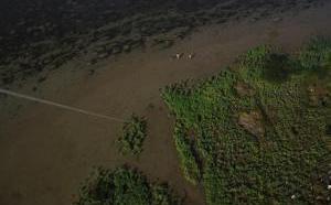
More than three years after the BP disaster, and a couple of years after the “clean up” has ended, the impacts of BP’s oil on Louisiana marshes remain.
Although the Coast Guard has stood down, there remains a need to monitor the sensitive salt marshes. This is left to the Louisiana communities most affected by the BP disaster. Public Lab, with Gulf Restoration Network, has received some funding to montior the heavily-oiled wetlands of Barataria Bay, but the full goal of empowering those most affected by BP’s impact requires the next step.
With your help, Public Lab and GRN staff will organize several outreach and training sessions, so that the people of Barataria Bay can learn low-cost aerial monitoring and annotate the resulting maps themselves.
Because many on the Gulf Coast fall on one side of the community divide, printed maps are an essential part of outreach. The maps that Public Lab printed of oiled marshes in Barataria Bay in 2011 were very popular along the coast, and we seek to update people on the status of their wetlands the way that they engage information.
Other funds will go to finalization of these community maps, so that people around the world will be able to view them via the Google Earth Platform.
Gulf Restoration Network and Public Lab will hold trainings and mapping sessions with Gulf leaders to learn low-cost mapping techniques, but also learn how the Barataria landscape has changed since 2011.
The impacts of BP’s oil on the Barataria ecosystem will unfold over decades. As Gulf communities struggle to adapt to an altered ecosystem, low-cost environmental monitoring techniques can provide a window into the world around us, as well as a compelling method of communicating our environmental challenges post-BP. In line with the Gulf Future goals, GRN and PublicLab can train Barataria residents with the ability to monitor their environment, to hold government and BP accountable for restoration of Barataria Bay marshes.
In late Winter 2014, we will hold several training, mapping, and annotation sessions with local residents to complete a second round of high-quality maps based upon low-altitude aerial photography methods Public Lab pioneered in 2010. By spring, and the fourth anniversary of the disaster, we will be able to present, among ourselves and to the media and scientific conferences, some results of a community-led mapping of BP’s impacts.
 +1-786-628-7980
 Sign Up/Sign In