Mountain Province Diamonds Inc. provides an update for its 100%-held Kennady North Project. The Kennady North Project covers 22 federal leases and 97 claims that include the new eastern claims that were acquired in early 2020. With the acquisition of the eastern claims, the Kennady North Project now totals 106,202 hectares and completely surrounds the Gahcho Kué Mine. Mountain Province is a 49% participant with De Beers Canada in the Gahcho Kué diamond mine.
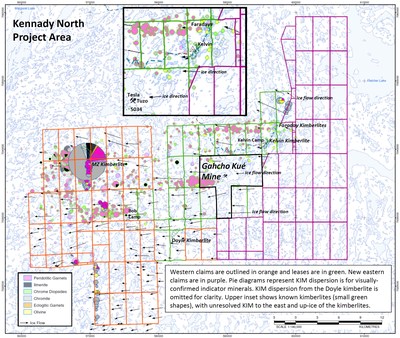


The eastern claims were acquired after in-house data suggested that kimberlite indicator minerals (‘KIM’) continued up-ice and east of the known kimberlite occurrences, including the kimberlites at Gahcho Kué. The KIM dispersion for Kennady North is shown in the image below with the inset image detailing KIM that are present east of the known kimberlites.
The Company has also completed a detailed glacial geology study on the eastern claims that is similar to the study conducted in 2018 by Palmer™ (Vancouver, BC) on the western claims and leases. The 2021 Palmer study incorporates field mapping and remote imagery data to identify glacial materials that are most amenable for recovery of KIM, and for tracking those KIM back to a primary source. Summer 2021 till sampling on the eastern claims is nearly complete with 327 samples being collected under guidance from the 2021 Palmer study. An additional 298 till samples were also collected from the western Kennady claims.
The Company gratefully acknowledges the receipt of a Minerals Incentive Program (MIP) award from the Government of Northwest Territories. The MIP award will help to offset costs of the first-year exploration activities on the eastern claims.
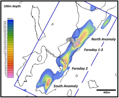
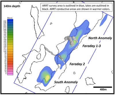
For an area of interest surrounding the Faraday kimberlites, a new ground-based resistivity method was tested for the first time. The Aurora Rapid Reactance Tomography (‘ARRT’) system developed by Aurora Geoscience Ltd (Yellowknife, NT) is a proprietary capacitive-coupled resistivity system that provides greater resolution and depth penetration over potential kimberlite targets compared to historical OhmMapper technology.
The ARRT survey was conducted during the winter 2021 program with snow-machine support. Line spacing was 40m, 80m and 160m depending on proximity to known kimberlites. Line traverse repeats were conducted in opposite directions over roughly the same lines to better resolve the 3D model. Roughly 650 line-km of ARRT data were collected over three days during the winter 2021 program.
Two plan-view slices of the ARRT results at 100m and 140m depth are shown in the images below. To the northeast of Faraday 1-3 and the southwest of Faraday 2 are two ARRT anomalies with expressions that are similar to those associated with the nearby Faraday bodies. These untested target areas are called the North and the South Anomalies.
Previous conductivity, resistivity, gravity, and electromagnetic surveys at Kennady North have shown that only very subtle physical contrasts are evident between the kimberlite and the country rock through which it is emplaced. The ARRT results suggest that a physical contrast can be detected between country rock immediately adjacent to the Faraday kimberlites that was broken and brecciated during kimberlite emplacement, and unbroken country rock occurring further away from the kimberlites.
Limited exploration drilling near the South Anomaly in 2018 (drillholes KDI-18-14a,b; KDI-18-15) intersected kimberlite from 0.11m to 5.41m in length as well as broken country rock (see News Release, May 23, 2018). None of these three historic drillholes were oriented in such a way as to properly test the South Anomaly. No historic drilling has been conducted near the North Anomaly. Drill-testing of both of these anomalies is a priority for the winter 2022 exploration season.
In addition to the 2021 Palmer study and the ARRT survey, there is a significant amount of historical geophysical coverage over the Kennady North Project. This includes 3,960 line-km of airborne gravity, over 30,000 ground gravity stations, 610 line-km of ground magnetics, and over 3,000 line-km of OhmMapper resistivity data, as well as bathymetry, HLEM, GPR, and ELF surveys over specific target areas. Numerous anomalies generated from these surveys require further ground-truthing and eventual drill-testing. Details of these surveys and their associated anomalies can be found in technical reports filed with SEDAR in 2017 and 2020, which are also available on the Company website.
The remainder of the summer 2021 exploration program will focus on completing the till sampling program with the samples to be shipped to SRC (Saskatoon, SK) for recovery of KIM. The processing results from SRC should be received in early 2022, before the start of the winter exploration season.
Activities that continue to advance the Kennady assets include under-ice water quality and fish habitat sampling, collection of historical drill samples for geochemical analysis of host rock, breeding bird and waterfowl surveys, and open-water fish, water quality, and hydrological monitoring programs. Seasonal water quality, hydrological, and fish and fish habitat sampling will continue through 2021. Community and regulatory engagement will also continue through the remainder of 2021. All activities related to the Kennady asset advancement are managed through Dr. April Hayward, Vice President Kennady North Project Sustainable Development.
Stuart Brown, the Company’s President and Chief Executive Officer, commented:
“With the advancement of the Kelvin and Faraday kimberlites, we’re taking advantage of the winter 2022 drilling season to test some attractive targets which have the potential to add to the resource base at Kennady North. Given the proximity to Gahcho Kué, any resource addition would only improve the potential for mine-life extension and increased value for shareholders.
We look forward to the results of the 2022 drill program, and commend Aurora Geosciences for their development of the innovative Aurora Rapid Reactance Tomography (‘ARRT’) technology which helped identify these high-potential targets.”
About the Company
Mountain Province Diamonds is a 49% participant with De Beers Canada in the Gahcho Kué diamond mine located in Canada’s Northwest Territories. The Gahcho Kué Joint Venture property consists of several kimberlites that are actively being mined, developed, and explored for future development. The Company also controls 106,202 hectares of highly prospective mineral claims and leases surrounding the Gahcho Kué Mine that include an Indicated mineral resource for the Kelvin kimberlite and Inferred mineral resources for the Faraday kimberlites. Kelvin is estimated to contain 13.62 million carats (Mct) in 8.50 million tonnes (Mt) at a grade of 1.60 carats/tonne and value of US$63/carat. Faraday 2 is estimated to contain 5.45Mct in 2.07Mt at a grade of 2.63 carats/tonne and value of US$140/ct. Faraday 1-3 is estimated to contain 1.90Mct in 1.87Mt at a grade of 1.04 carats/tonne and value of US$75/carat. All resource estimations are based on a 1mm diamond size bottom cut-off.
For further information on Mountain Province Diamonds and to receive news releases by email, visit the Company’s website at www.mountainprovince.com.
 +1-786-628-7980
 Sign Up/Sign In