Study of the World’s largest lava lake
The project “Nyiragongo 2017 Scientific Expedition” is a scientific initiative aiming at studying in details the eruptive activity of the dangerous African volcano: Mount Nyiragongo.

This expedition represents a new chapter of an amazing adventure started 12 years ago by Belgian and Luxembourgian scientists. This is the story of a fascinating-but-dangerous volcano. This is the story of scientists who want to make sense to their research. This is the story of a local population that counts on these scientists to avoid the worst when Nyiragongo will start to grow dark again.


CONTEXT
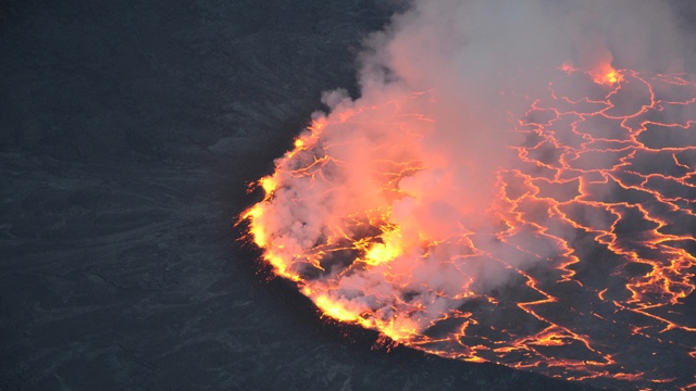
Nyiragongo directly threatens a population roughly estimated to 1 million persons. This volcano already produced to disastrous flank eruptions, in 1977 and 2002. Its current activity corresponds to the presence of a persistent lava lake (the largest on Earth) in its main crater.

Nyiragongo and one of the disastrous lava flows of January 2002. (false-color image in which vegetation appears red)
(c) publicbooks.org, 2010
The Nyiragongo lava lake is no monitored yet, despite the fact that its level variations may provide crucial information of the magma pressure state inside the volcano. This would help detect signs of a potential upcoming and dangerous flank eruption.
THE PROJECT
During a perilous scientific expedition planned in June 2017, I will go down into the main crater of Nyiragongo, with several colleagues, in order to measure surface and vertical variations of the lava lake for several days.


The main goal of this 12-day summit expedition, where we will sleep inside the active crater, is to quantify the lava lake activity and next compare the data with geophysical parameters used for the monitoring of the volcano. Typical examples of these geophysical parameters are seismic activity, ground deformation and gas emissions. Thanks to that, we will be able to better interpret how geophysical parameters translate the volcanic activity and, as a consequence, better detect any variation of activity that may lead to a dangerous eruption.

Overflow of the Nyiragongo lava lake, in September 2011. (c) N. d’Oreye, 2011
METHODOLOGY
In order to do that, I plan to install several cameras around the lava lake, in the crater, which will take photos of it at the same time, in time-lapse mode. Each dataset of images acquired at the same time, but at different viewpoints, will allow the 3D modellling of the lava lake. Hence, by comparing the produced 3D models, I will be able to measure any lava lake level and surface change that occurred between two sets of acquisition.

3D model of the Nyiragongo crater, produced by photogrammetry
The camera equipment is homemade and the first prototype has been funded by my salary. To develop the full methodology in the Nyiragongo crater, I need to build 4 time-lapse camera systems like that.

WHY THIS CROWDFUNDING CAMPAIGN
In Belgium, it is quite difficult to finance fundamental research in the fields of Earth Sciences, especially for the few last years. Currently, I am without any financial support for the development of the scientific equipment required for this expedition. If I have supports from my institituion, the non-profit organization “ESO Research” and BBC (British public television) for the costs related the the organization od the expedition, my only sponsor for the scientific equipment is … myself. Financially stuck, I have developed this crowdfunding campaign to allow the realization of the scientific objectives.
In order to develop this in a constructive manner and with a long-term perspective, I realize the crowdfunding through ESO Research. This will allow the developed equipment to be available and used for other research projects after the expedition. Hence, your contribution to the project will not be a “one shot” and will benefit to other young and promising scientists.
The budget required for the project has been divided into 3 levels; each level reached unlocking the possibility to use a specific equipment. The first level is essential. The two other upper levels will insure a top quality expedition, with the acquisition of unique and diversified data that will provide work on Nyiragongo for years.
Level 1: Mutli-View Time-Lapse Camera System (4,200 euros)
The minimum budget for the project to be a success is 4,200 euros. This corresponds to the development of 4 time-lapse cameras adepted to the specific context (acid gases, high humidity, recurrent rain and hail storms, etc.) of the Nyiragongo crater. The amount also includes admin and retribution fees.
What I call here a “Mutli-View Time-Lapse Camera” System (or MVTLC) corresponds to a series of synchronized 8Mpix. optical to near-infrared cameras, controlled with micro-computers (Raspberry Pi). In order to avoid clock drift during image acquisition, time measurement is performed with a precision real-time clock able to compensate the effects of temperature. Acquired images will be stored on an external hard disk drive and power supply will be insured by a series of external batteries that will be replaced regularly during the expedition.
Minimum 4 cameras with convergent viewpoints are required to accurately reconstruct the crater bottom and the lava lake in 3 dimensions.The reason why cameras ranging from the visible to the near-infrared spectrum are used is because they will allow to partially see through the gas plume. These cameres will hence provide a better visibility on the lava lake. The synchronized acquisitions will be planned at a rate of 3 to 60 images/minute, depending on the eruptive activity of the lava lake during the summit expedition.
Level 2: High-temperature Thermal Camera System (9,000 euros)
If this second level is reached, a thermal camera will be used to mesure the dynamics of the lava lake. The great advantage of such a system is its ability to see through the gas plume an measure temperature contracts accurately. The amount of the 2nd level corresponds to the cost of the high-temperature thermal camera (~7,500 euros), the associated software and fees related to the campaign (retributions, admin fees).
Level 3: MVTLC System + Thermal Camera System (13200 euros)
This ultime level will allow the development of the two techniques proposed in the two lower levels, i.e., a network of time-lapse cameras and a thermal camera calibrated for high temperatures. Thanks to the level 3, I will be able to gather all the required data to fully understand the dynamics of the lava lake through different time scales. Collected data will provide work for years and I will be able to consider developping a long-term monitoring system for the lava lake based on the experience of the expedition and the obtained results. Collected data will also help me to find new funds to continue studying this highly active and dangerous volcano that is Nyiragongo.

My name is Benoît Smets. I am a young doctor in science working in the fields of volcanology and natural risks, for the Royal Museum for Central Africa, in Belgium. During the 10 first years of my career, I focused on a specific region of Central Africa: The Virunga Volcanic Province, east of the Democratic Republic of Congo, where two of the most active African volcanoes are located, i.e., Nyiragongo and Nyamulagira.


Nyiragongo and Nyamulagira directly threaten a population of more thant 1 million persons. The main goals of my research and the work of my close collaborators are simple: to improve scientific knowledge, volcano monitoring and hazard assessment for these volcanoes.
Through our research projects, we also provide training and capacity building for our Congolese partners, in order to transfer a maximum of skills locally, whether for fundamental research, volcano monitoring or risk management in the area.
The fact that we work at these different levels makes a lot of sense to our work, as our results are beneficial for both science and society. Hence, you would easily understand the passion that drives us.
For more information about my research and the Virunga volcanoes, do not hesitate to visit the following two web sites:
 +1-786-628-7980
 Sign Up/Sign In